

The Niagara Falls are voluminous waterfalls on the Niagara River, straddling the international border between the Canadian province of Ontario and the U.S. state of New York. The falls are 17 miles (27 km) north-northwest of Buffalo, New York and 75 miles (120 km) south-southeast of Toronto, Ontario, between the twin cities of Niagara Falls, Ontario, and Niagara Falls, New York.
Niagara Falls is composed of two major sections separated by Goat Island: Horseshoe Falls, the majority of which--two-thirds according to the US Geological Survey--lies on the Canadian side of the border, and American Falls on the American side. The smaller Bridal Veil Falls are also located on the American side, separated from the main falls by Luna Island.
Niagara Falls were formed when glaciers receded at the end of the Wisconsin glaciation (the last ice age), and water from the newly formed Great Lakes carved a path through the Niagara Escarpment en route to the Atlantic Ocean. While not exceptionally high, the Niagara Falls are very wide. More than 6 million cubic feet (168,000 m³) of water falls over the crest line every minute in high flow, and almost 4 million cubic feet (110,000 m³) on average. It is the most powerful waterfall in North America.
The Niagara Falls are renowned both for their beauty and as a valuable source of hydroelectric power. Managing the balance between recreational, commercial, and industrial uses has been a challenge for the stewards of the falls since the 1800s.
Characteristics
Niagara Falls is divided into the Horseshoe Falls and the American Falls. The Horseshoe Falls drop about 173 feet (53 m), the height of the American Falls varies between 70–100 feet (21–30 m) because of the presence of giant boulders at its base. The larger Horseshoe Falls are about 2,600 feet (790 m) wide, while the American Falls are 1,060 feet (320 m) wide.
The volume of water approaching the falls during peak flow season may sometimes be as much as 202,000 cubic feet (5,700 m3) per second. Since the flow is a direct function of the Lake Erie water elevation, it typically peaks in late spring or early summer. During the summer months, 100,000 cubic feet (2,800 m3) per second of water actually traverses the Falls, some 90% of which goes over the Horseshoe Falls, while the balance is diverted to hydroelectric facilities. This is accomplished by employing a weir with movable gates upstream from the Horseshoe Falls. The Falls flow is further halved at night, and during the low tourist season in the winter, remains a flat 50,000 cubic feet (1,400 m3) per second. Water diversion is regulated by the 1950 Niagara Treaty and is administered by the International Niagara Board of Control (IJC).Viewpoints on the American shore generally are astride or behind the falls. The falls face directly toward the Canadian shore.
The volume of water approaching the falls during peak flow season may sometimes be as much as 202,000 cubic feet (5,700 m3) per second. Since the flow is a direct function of the Lake Erie water elevation, it typically peaks in late spring or early summer. During the summer months, 100,000 cubic feet (2,800 m3) per second of water actually traverses the Falls, some 90% of which goes over the Horseshoe Falls, while the balance is diverted to hydroelectric facilities. This is accomplished by employing a weir with movable gates upstream from the Horseshoe Falls. The Falls flow is further halved at night, and during the low tourist season in the winter, remains a flat 50,000 cubic feet (1,400 m3) per second. Water diversion is regulated by the 1950 Niagara Treaty and is administered by the International Niagara Board of Control (IJC).Viewpoints on the American shore generally are astride or behind the falls. The falls face directly toward the Canadian shore.
History
There are differing theories as to the origin of the name of the falls. According to Iroquoian scholar Bruce Trigger, "Niagara" is derived from the name given to a branch of the locally residing native Neutral Confederacy, who are described as being called the "Niagagarega" people on several late 17th century French maps of the area.
A number of figures have been suggested as first circulating an eyewitness description of Niagara Falls. Frenchman Samuel de Champlain visited the area as early as 1604 during his exploration of Canada, and members of his party reported to him the spectacular waterfalls, which he described in his journals. Finnish-Swedish naturalist Pehr Kalm explored the area in the early 1700s and wrote of the experience. The consensus honoree is Belgian Father Louis Hennepin, who observed and described the Falls in 1677, earlier than Kalm, after traveling with explorer René Robert Cavelier, Sieur de la Salle, thus bringing the Falls to the attention of Europeans. Further complicating matters, there is credible evidence that French Jesuit Reverend Paul Ragueneau visited the Falls some 35 years before Hennepin's visit, while working among the Huron First Nation in Canada. Jean de Brébeuf also may have visited the Falls, while spending time with the Neutral Nation.
A number of figures have been suggested as first circulating an eyewitness description of Niagara Falls. Frenchman Samuel de Champlain visited the area as early as 1604 during his exploration of Canada, and members of his party reported to him the spectacular waterfalls, which he described in his journals. Finnish-Swedish naturalist Pehr Kalm explored the area in the early 1700s and wrote of the experience. The consensus honoree is Belgian Father Louis Hennepin, who observed and described the Falls in 1677, earlier than Kalm, after traveling with explorer René Robert Cavelier, Sieur de la Salle, thus bringing the Falls to the attention of Europeans. Further complicating matters, there is credible evidence that French Jesuit Reverend Paul Ragueneau visited the Falls some 35 years before Hennepin's visit, while working among the Huron First Nation in Canada. Jean de Brébeuf also may have visited the Falls, while spending time with the Neutral Nation.

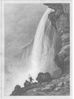
Man and woman on Canadian side of Niagara Falls, circa 1858
Maria Spelterini crossing the Niagara gorge on a tightrope on July 4, 1876
During the 18th century, tourism became popular, and by mid-century, it was the area's main industry. Napoleon Bonaparte's brother Jérôme visited with his bride in
the early 19th century. In 1837 during the Caroline affair a rebel supply ship, the Caroline, was burned and sent over the Falls. In 1848, the falls actually went dry; no water (or at best a trickle) fell for as much as 40 hours. Waterwheels stopped, mills and factories simply shut down for
having no power. Later that year demand for passage over the Niagara River led to the building of a footbridge and then Charles Ellet's Niagara Suspension Bridge. This was supplanted by German-born John Augustus Roebling's Niagara Falls Suspension Bridge in 1855. After the American Civil War, the New York Central railroad publicized Niagara Falls as a focus of pleasure and honeymoon visits. With increased railroad traffic, in 1886, Leffert Buck
replaced Roebling's wood and stone bridge with the predominantly steel bridge that still carries trains over the Niagara River today. The first steel archway bridge near the Falls was completed in 1897. Known today as the Whirlpool Rapids Bridge, it carries vehicles, trains, and pedestrians between Canada (through Canadian Customs Border Control) and the U.S.A. just bel
ow the Falls. In 1941 the Niagara Falls Bridge Commission completed the third current crossing in the immediate area of Niagara Falls with the Rainbow Bridge, carrying both pedestrian and vehicular traffic between the two countries and Canadian and U.S. customs for each country.

The features that became Niagara Falls were created by the Wisconsin glaciation, about 10,000 years ago. The same forces also created the North American Great Lakes and the Niagara River. All were dug by a continental ice sheet that drove through the area, deepening some river channels to form lakes, and damming others with debris. Scientists believe that there is an old valley, buried by
ncWhen the ice melted, the upper Great Lakes emptied into the Niagara River, which followed the rearranged topography across the Niagara Escarpment. In time, the river cut a gorge through the north facing cliff, or cuesta. Because of the interactions of three major rock formations, the rocky bed did not erode evenly. The top rock formation was composed of erosion-resistant limestone and Lockport dolostone. That hard layer of stone eroded more slowly than the underlying materials. The aerial photo clearly shows the hard caprock, the Lockport Formation (Middle Silurian), which underlies the rapids above the Falls, and approximately the upper third of the high gorge wall.
Immediately below the hard-rock formation, comprising about two thirds of the cliff, lay the weaker, softer, sloping Rochester Formation (Lower Silurian). This formation was composed mainly of shale, though it has some thin limestone layers. It also contains ancient fossils. In time, the river eroded the soft layer that supported the hard layers, undercutting the hard caprock, which gave way in great chunks. This process repeated countless times, eventually carving out the Falls.
Submerged in the river in the lower valley, hidden from view, is the Queenston Formation (Upper Ordovician), which is composed of shales and fine sandstones. All three formations were laid down in an ancient sea, their differences of character deriving from changing conditions within that sea.
The Niagara Falls at one time in history was located between present-day Queenston, Ontario, and Lewiston, New York, but erosion of their crest has caused the waterfalls to retreat approximately 6.8 miles or 11 kilometers southward. The Horseshoe Falls, which are approximately 2,600 feet (790 m) wide, have also changed their shape through the process of erosion; evolving from a small arch, to a horseshoe bend, to the present day gigantic inverted . Just upstream from the Falls' current location, Goat Island splits the course of the Niagara River, resulting in the separation of the Canadian Horseshoe Falls to the west from the American and Bridal Veil Falls to the east. Engineering has slowed erosion and recession.
ไม่มีความคิดเห็น:
แสดงความคิดเห็น